
In November 2024, every commercial superintendent who’d been running StructionSite on their iPhone for the past five years woke up inside a different product. Their data, their projects, their floor plans, their 360-degree walk archives — all migrated overnight to DroneDeploy Ground. The company that bought StructionSite back in October 2022 finally folded the brand into its own platform, and the product that 5.0 stars across 152 iOS reviews had been calling “StructionSite Construction App” became “DroneDeploy Ground” on the same login.
That migration is the editorial story for May 2026 — but it’s not the whole product. DroneDeploy in 2026 is two products under one platform: Aerial (the drone-photogrammetry tool the company has shipped since 2013) and Ground (the ex-StructionSite 360-degree-walk product). Same login. Same project hierarchy. Same AI engine running across both — Progress AI claiming 95-percent accuracy across 80-plus trades, Safety AI auto-flagging hazards, Inspection AI handling predictive maintenance for energy and rail.
“If a picture is worth a thousand words; a 360 photo is worth a million.” — Albert Zulps, Director of Emerging Technology, DroneDeploy Ground product page
This review covers what the unified platform actually does, what it costs (Aerial pricing is published, Ground is sales-only), what the AI stack ships in 2026 versus what’s still on the roadmap, where DroneDeploy fits in the commercial-construction stack alongside Procore and Autodesk Construction Cloud, what carried over from StructionSite versus what changed, and which contractors should be running CompanyCam instead because they’re not the audience DroneDeploy is built for.
What DroneDeploy Actually Is (Two Products, One Platform)
The positioning question matters because most contractor readers come into a DroneDeploy review with one of two mental models: “the StructionSite successor” or “the drone software.” Both are right. Neither is complete.
DroneDeploy Aerial is the original product. Founded 2013 in San Francisco, the company built its category around drone photogrammetry — a contractor flies a DJI Mavic, Mini, or M30-series drone over an outdoor site; the platform processes the imagery into orthomosaics, 3D models, point clouds, and volumetric measurements. Use cases: earthworks volumes for heavy-civil contractors, site progress flyovers for commercial GCs, agricultural field analysis, mining stockpile measurement, and inspection workflows for utilities, rail, and renewables.
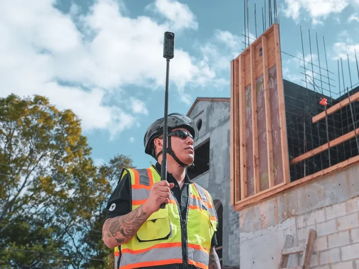
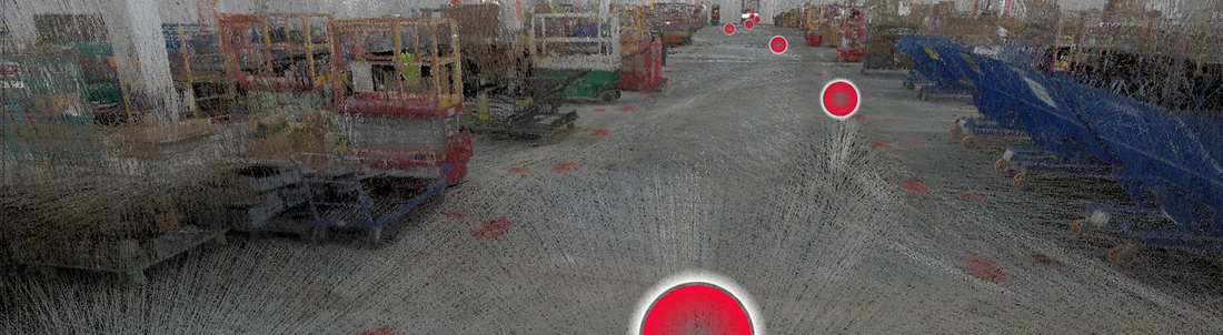
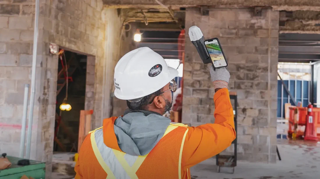
DroneDeploy Ground is what StructionSite became. Acquired October 2022, sunset November 1, 2024, migrated under the DroneDeploy login. The capture workflow is hard-hat-mount: a superintendent walks the building with an Insta360 X5 (or X4, ONE RS 1-inch, or Ricoh Theta X) on a monopod, AI auto-pins each 360-degree photo to its location on the floor plan, and the captured walk gets compared against the BIM model in the office for design-vs-reality verification.
The unified play is what DroneDeploy markets in 2026. A commercial GC running both Aerial flyovers and Ground interior walks on the same project doesn’t coordinate two vendors and two data lakes — it’s one platform, one project, one Procore-integrated reality-capture record. That’s the editorial difference between DroneDeploy and a focused competitor like OpenSpace (Ground-only) or DJI Terra (Aerial-only).
How DroneDeploy Ground Works in Practice
This is the half most contractor readers came here for, so it gets the most space.
The capture workflow goes like this. A superintendent or foreman opens the DroneDeploy app on their iPhone or iPad, selects the project, and either picks a path to walk (linear capture) or marks specific zones to cover. They mount the 360-degree camera on the monopod or hard-hat mount, hit record, and walk the building. The mobile app syncs the camera’s video or photo stream over Bluetooth, captures GPS where signal permits, and queues the upload. Back in the office or over WiFi, the platform processes the walk: AI auto-aligns each frame against the floor plan (the original “Vision Engine” that StructionSite shipped, now native to DroneDeploy Ground), tags photos by spatial location, and makes the captured walk searchable from the web app.
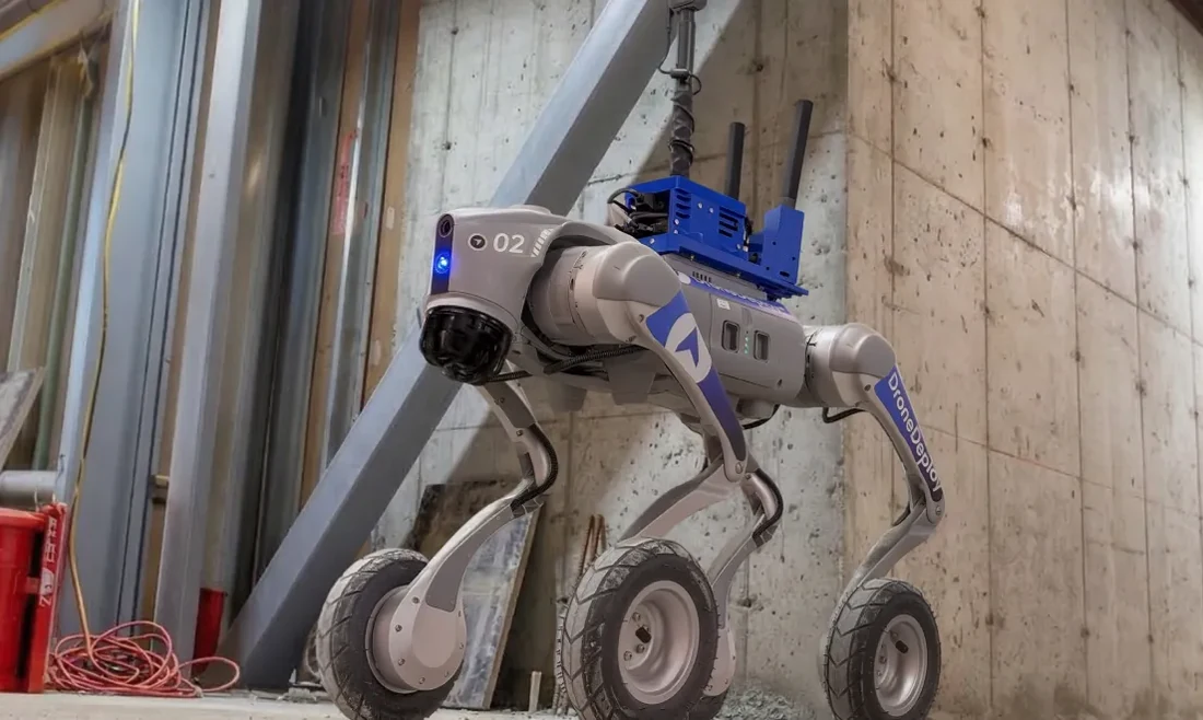
Hardware support as of May 2026: Insta360 X5 (newest, dual 1-inch sensors, added October 2025), Insta360 X4, Insta360 ONE RS 1-inch, Ricoh Theta X. The platform accepts both .INSV and .MP4 formats. For autonomous capture, Boston Dynamics Spot and the OnSight ground robot can both walk a site without a human operator — Turner Construction reports 95-percent-plus inspection-time reduction running Spot for autonomous walks.
Plan ingestion happens via PDF drawings, BIM models in Revit or IFC format, or auto-sync from Autodesk Construction Cloud (added October 2025) or Procore Drawings. The April 2025 release added level-by-level BIM calibration — important for legacy StructionSite migrated projects that didn’t have aligned levels.
BIM Compare is the flagship verification feature. The October 2025 release added side-by-side BIM-vs-360-panorama comparison and a “Replace BIM” button that preserves spatial alignments when the design model gets revised — the company claims a 75-percent rework reduction on alignment workflow. For a commercial GC running BIM coordination meetings, this is the layer that makes the platform sticky.
Reports ship as branded PDFs covering progress, safety findings, defects, and BIM-compare exports. The October 2025 release added auto-sync to Autodesk Construction Cloud for BIM, bidirectional model updates, and DJI Mini 4 Pro support on the Aerial side.
How DroneDeploy Aerial Works (And Why Most Residential Contractors Don’t Need It)
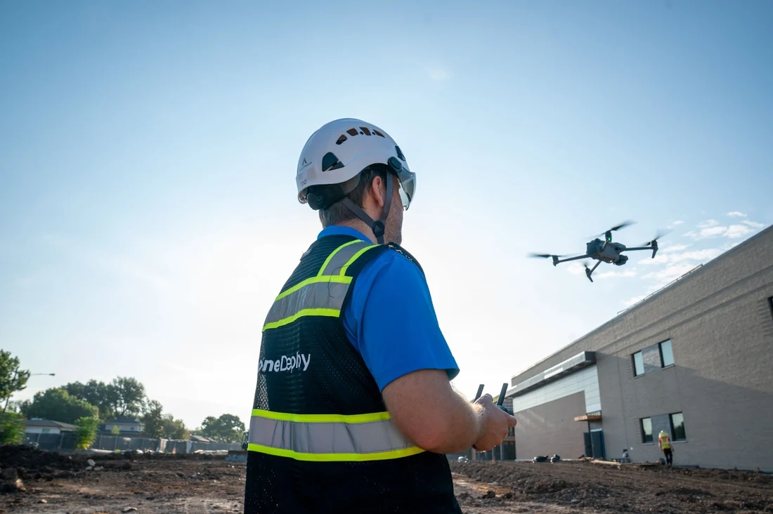
The Aerial side is what built DroneDeploy. A contractor flies a drone over an outdoor site (DJI Mavic/Mini/M30 series are the most-used; DJI Mini 4 Pro support added October 2025). The platform processes the imagery into:
- Orthomosaics — high-resolution top-down composites that cover the whole site
- 3D models — photogrammetric reconstructions usable for measurement and BIM coordination
- Point clouds — exportable for downstream surveying workflows
- Volume calculations — stockpile, cut/fill, earthworks volumes from the same imagery
- Site progress — week-over-week and month-over-month comparison views
Use cases that fit:
- Heavy-civil and earthworks contractors measuring stockpile and cut/fill volumes weekly
- Commercial GCs documenting site progress for owners on large outdoor projects (data centers, healthcare campuses, multifamily complexes)
- Mining and energy operations for stockpile management and inspection
- Agricultural operations using DroneDeploy Ag (the entry-level $1,908/year tier)
- Utility, rail, and renewables inspection via Inspection AI’s predictive-maintenance workflow
Use cases that don’t fit:
- Residential roofing contractors measuring individual roofs — EagleView and Hover serve them with pre-flown imagery; you don’t need to fly your own drone
- Residential remodelers doing additions and kitchens — drone flyovers add nothing to a single-family workflow
- Service-trade businesses (HVAC, plumbing, electrical) — there’s no Aerial use case at all
For contractors who don’t already own and operate drones, the Aerial side is editorial color, not a buying reason. The Ground product is what most contractor readers should evaluate.
What DroneDeploy Costs in 2026
Pricing transparency on the Aerial side is unusually good for a commercial-construction platform; pricing transparency on the Ground side is genuinely opaque.
Aerial pricing is on the public pricing page. Ground tier pricing is sales-only — plan for two-to-three discovery calls.
14-day free trial, no credit card. Annual billing saves ~30% versus monthly on individual Aerial plans. Demand renewal pricing in writing before signing — enterprise SaaS in this category routinely escalates 15-30% at year-two.
The honest read on pricing: for a 25-person commercial GC running Ground across 4-6 active projects, expect annual contracts in the high four-figures to low five-figures based on aggregator-sourced ranges. Implementation and training fees aren’t publicly disclosed; ask. The Ground Pro Beta tier (announced for 2026, adds mobile LiDAR, RTK, and 8K imagery) doesn’t have published pricing yet either.
If your operation can’t tolerate two-to-three discovery calls before you see a real number, this isn’t the product for you, and that’s a structural fit issue more than a complaint.
The AI Stack: Three Products, One Engine
This is where DroneDeploy has pulled clear daylight on most photo-documentation competitors in 2025-2026.
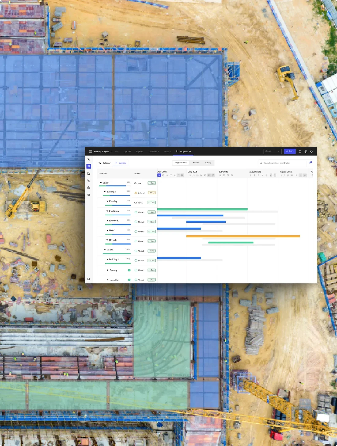
Progress AI launched July 2025 and is the headline. Tracks 80-plus trade types with claimed 95-percent accuracy. Delivers reports within 2 hours of upload. Requires no BIM model or schedule prerequisite — the AI infers progress from imagery alone. Used on 3-million-plus sites in 180 countries. The contractor-relevant claim: percent-complete by trade across the project, derived from imagery rather than a manually-maintained schedule.
Safety AI got a unified dashboard in April 2025 after several years of incremental hazard-detection features. Auto-detects fall protection, PPE compliance, and hazardous conditions across captured imagery with 90,000-plus detections to date. Customer-enabled with project-level enable/disable controls — useful for operations where safety-AI alerts could create labor-relations friction if turned on without crew briefing.
Inspection AI handles predictive maintenance for oil and gas, rail, renewables, and utilities. Visual review with severity ranking. Exports to asset-management systems. Most contractor readers won’t use Inspection AI; it’s relevant for energy-side and infrastructure operators.
The 2026 roadmap announced at Horizons 2025 added embodied-AI ground robots in beta deployments (Boston Dynamics Spot is already in production with Turner Construction; OnSight ground robots add autonomous UGV capture with thermal imaging), Gaussian Splats for 3D capture, mobile RTK for surveying-grade positioning, and automated earthworks calculation. The “zero robotics knowledge required” framing matters — DroneDeploy is explicitly trying to remove the human from routine inspection-walk capture.
Versus Procore Copilot specifically: different shape entirely. Procore Copilot is conversational AI across the broader project-management platform (“show me all RFIs from last month with cost-impact”); DroneDeploy AI is reality-capture-domain-specific (“what percent-complete is the framing on level 4?”). Most enterprise commercial GCs run both — they’re complementary, not competing. Versus Raken AI: Raken’s three features (Photo Tagging, Photo ID, Daily Report Summaries) are utility-narrow; DroneDeploy AI is broader and deeper, especially on percent-complete-by-trade quantification. Versus CompanyCam AI: roughly even on photo tagging maturity but DroneDeploy’s plan-pinning automation goes deeper because the underlying capture model (360-degree spatial walks with BIM alignment) gives the AI more spatial context to work with.
Integrations: Commercial-Construction-Native, Residential-Trade-Absent
The integration story is the cleanest single fit signal in DroneDeploy’s value proposition.
What DroneDeploy IS natively integrated with:
- Procore — DEEP. First reality-capture platform to integrate Procore BIM in 2021. Embedded App lives inside Procore’s UI. Photos sync to Procore Albums twice daily. RFI creation directly on 360-degree photos. Drawings auto-sync. Procore credentials handle SSO. The October 2025 release deepened the integration further with bidirectional model updates.
- Autodesk Construction Cloud + Autodesk Build — auto-sync for BIM added October 2025, bidirectional model updates, “Replace BIM” preserving alignment.
- BIM 360 — yes, the legacy Autodesk integration.
- Bluebeam — listed in DroneDeploy’s app marketplace, depth on Ground specifically unverified during research.
- Cloud storage — Box, Google Drive, OneDrive, SharePoint, Egnyte, Dropbox, ShareFile, Amazon S3.
- GIS — ArcGIS Online, Esri.
What DroneDeploy is NOT integrated with — verified May 4, 2026:
| Tool | Native? | Why it matters |
|---|---|---|
| JobNimbus | No | Roofing CRM — different market |
| Jobber | No | Residential service FSM |
| Housecall Pro | No | Residential service FSM |
| ServiceTitan | No | Service-trade FSM |
| AccuLynx | No | Roofing/insurance CRM |
| GoHighLevel | No | Marketing automation |
| Smith.ai | No | AI receptionist (different category) |
| CompanyCam | No | Competing photo-doc product |
| Raken | No | Adjacent commercial daily-reports |
| Buildertrend | No | Residential GC platform |
| Fieldwire | No | Adjacent field-PM product |
Practical implication: if your operation runs the residential-trade FSM stack, DroneDeploy is structurally the wrong product. It’s built for commercial GCs running Procore and Autodesk, and its integration roster reflects that by design — not by oversight. If you came in expecting DroneDeploy to slot into a Jobber + JobNimbus + AccuLynx workflow, CompanyCam is what you actually want. CompanyCam ships those native integrations, has cleaner photo organization for the residential photo-with-job model, and costs an order of magnitude less per seat.
For the marketing-automation-plus-FSM case that comes up often in residential service trades — running Jobber + GoHighLevel as a paired stack under $400 a month combined — DroneDeploy doesn’t slot in there either. That’s a different stack for a different audience entirely.
What Real Contractors Say (And Why the Sample Is Thin)
The customer-sentiment data on DroneDeploy in 2026 is harder to source than for most products on this hub, and that’s worth being honest about.
The pre-acquisition StructionSite Capterra listing went inactive after the November 2024 sunset. The current DroneDeploy Capterra listing has only 9 reviews dated 2020-2023 with a 4.1/5 average — and those reviews predate Progress AI, Safety AI, the Ground rebrand, and the 2026 product. G2 is similarly thin and absorbed StructionSite reviews into the DroneDeploy listing during the brand merge. Real customer-sentiment data has to come from named case studies and the customer-logo wall, which DroneDeploy publishes prominently — Turner, Rio Tinto, DPR Construction, Bayer, Skanska, BP, McCarthy Building Companies, Ryan Companies, Walsh Group, Clayco, AECOM, Layton Construction, Weitz, PCL.
A few verifiable named quotes worth pulling forward:
“If a picture is worth a thousand words; a 360 photo is worth a million.” — Albert Zulps, Director of Emerging Technology, DroneDeploy Ground product page
“They have made this software incredibly easy to use.” — Steven K., Pilot, Airlines/Aviation, Capterra 5/5 stars · September 19, 2023
“Everything has been seamless.” — Eric C., Safety Officer, Construction industry, Capterra 5/5 stars · December 13, 2021
“Software has fail twice causing the lost of 2 drones.” — Fernando G., CEO, Security & Investigations industry, Capterra 1/5 stars · September 10, 2020
The Fernando G. quote is the worth-taking-seriously critical one — drone-loss events on the Aerial side are a real risk pattern even if rare, and contractors flying $5,000-$20,000 DJI drones over their own jobsites should price the insurance and the hardware-loss math into the buying decision. The most-quoted production case study is Turner Construction’s deployment of Boston Dynamics Spot for autonomous walks, which the company cites as 95-percent-plus inspection-time reduction — a bigger ROI claim than the Capterra sample can validate, but verifiable through Turner’s own published case study.
For contractors who weight Capterra heavily, the data is genuinely thinner than CompanyCam (4.7 across 1,800-plus reviews) or Raken (4.6 across 248). The named-customer evidence is strong; the aggregated review evidence is weak. Both are real signals.
What Changed in 2025-2026
Three updates from the last twelve months are worth flagging.
StructionSite sunset (November 1, 2024). Paid customers migrated to DroneDeploy Ground. Founder Matt Daly is now General Manager of AEC and Integration at DroneDeploy. Co-founders Phillip Lorenzo and Dan Zito remain referenced. The legacy structionsite.com domain returns 403; logins now run through app.dronedeploy.com. Customer data, projects, and 360-degree walk archives migrated automatically.
April 2025 release. Insta360 X5 support announcement preview, customer-enabled Safety AI, high-performance minimap, offline deliverable filtering by date and level, BIM alignment by level (important for ex-StructionSite migrated projects), simplified project creation.
July 2025 — Progress AI launch. 95-percent accuracy claim across 80-plus trade types, 2-hour reports, no BIM-model or schedule prerequisite required.
Horizons 2025 (October). Three AI agents (Progress, Safety, Inspection), 2026 beta of embodied-AI ground robots, Gaussian Splats for 3D capture, mobile RTK, automated earthworks. Docked drones operating on 100-plus projects.
October 2025 release. Insta360 X5 fully supported, Autodesk Construction Cloud auto-sync for BIM, “Replace BIM” preserving alignment, BIM-vs-360-panorama compare side-by-side, DJI Mini 4 Pro support, geofences, manual flight override for docks.
2026 roadmap. Embodied-AI ground robot beta deployments (Spot already in production at Turner Construction). DroneDeploy Ground Pro tier with mobile LiDAR, RTK, and 8K imagery — pricing not yet announced.
Who Should Use DroneDeploy
Six contractor archetypes where DroneDeploy is editorially the right pick.
Commercial general contractors at $1M-plus revenue scale running Procore-coordinated jobs with BIM coordination requirements. The platform was built for you.
Specialty trade subcontractors on commercial jobs — concrete, framing, mechanical, electrical, drywall, glazing — required to submit progress documentation to a GC who runs Procore. You can run DroneDeploy without buying Procore yourself; data still flows into the GC’s Procore via the native integration.
Owner-developers managing portfolios of large interiors — data centers, healthcare campuses, multifamily complexes, industrial buildings — where the executive-level reporting layer is load-bearing.
Heavy-civil and earthworks contractors using drones for stockpile measurement, cut-fill volumes, and weekly site progress flyovers. The Aerial side is where DroneDeploy’s enterprise depth lives, and this is the audience that uses it most.
Industrial operations in oil and gas, rail, renewables, utilities, mining — Inspection AI handles the predictive-maintenance workflow at scale.
Compliance-heavy commercial operations running OSHA-driven safety programs where Safety AI’s auto-detection of PPE compliance and fall hazards is meaningful documentation.
Who Should NOT Use DroneDeploy
Six wrong-fit contractor archetypes with explicit redirects.
Residential remodelers and custom home builders — Buildertrend is purpose-built with native scheduling, customer portal, sales pipeline, selections, and proposal workflow that DroneDeploy doesn’t ship and isn’t trying to. Use Buildertrend.
HVAC, plumbing, and electrical service businesses — Workiz, ServiceTitan, Jobber, or Housecall Pro are the right tools. Multi-tech dispatch, recurring service plans, customer-facing booking, GPS routing — none of which DroneDeploy does, all of which you need. If you also want marketing automation and AI call answering on top, the Jobber + GoHighLevel paired stack under $400 a month combined is the right pairing — neither half integrates with DroneDeploy and that’s by design.
Roofing contractors with insurance work — JobNimbus or AccuLynx handle Xactimate scope, supplements, EagleView measurements, and the production-board workflow DroneDeploy doesn’t model. For roof-only measurement, EagleView and Hover serve pre-flown imagery without the contractor needing to fly drones at all.
Solo contractors and 1-5-person residential shops — DroneDeploy’s enterprise pricing structure plus commercial feature density is overkill. CompanyCam at $13/user/month for the residential photo-with-job model, or Contractor Foreman at $332/month flat for unlimited users, is the right cost-to-value fit.
Photo-doc-first residential operations where photos are 80-plus percent of the buying reason — CompanyCam has cleaner photo organization UX, deeper photo AI search, lower per-seat cost, and native integrations to JobNimbus, Jobber, AccuLynx, Buildertrend that DroneDeploy doesn’t ship. If you want CompanyCam’s clean residential workflow at residential pricing, get CompanyCam.
Operations needing transparent published pricing — DroneDeploy’s Ground tier is sales-quoted only. If you can’t tolerate two-to-three discovery calls before you see a number, the product isn’t going to fit and that’s a structural mismatch, not a vendor failing.
The Verdict
DroneDeploy in 2026 is the most defensible reality-capture platform for commercial construction, and the editorial moat is the unified Aerial-plus-Ground-plus-AI architecture. Two products under one platform, sharing one AI engine, integrating natively with the enterprise commercial-construction stack (Procore, Autodesk Construction Cloud, BIM 360, Bluebeam) and explicitly not integrating with the residential-trade FSM stack. Progress AI’s 95-percent-accuracy claim across 80-plus trades is the strongest AI claim in photo-documentation, and the 2026 ground-robot roadmap moves the platform toward autonomous capture in a way no competitor has matched.
The honest catches matter. Pricing on the Ground side is custom-quote, with two-to-three discovery calls before you see a real number. The Capterra sample is thin because the StructionSite-to-DroneDeploy brand merge wiped review history. Mobile workflow has known sharp edges that residential photo apps don’t share. Zero native integrations with the residential-trade FSM stack — by design, but disqualifying for that audience.
Buy DroneDeploy if you’re a commercial GC running Procore-coordinated jobs, a specialty sub on commercial work required to submit BIM-aligned documentation, an owner-developer with a portfolio of large interiors, a heavy-civil contractor measuring earthworks volumes, an industrial operator running predictive-maintenance inspection workflows, or a compliance-heavy commercial operation where Safety AI’s documentation layer is load-bearing.
Skip DroneDeploy entirely if you’re residential remodeling (use Buildertrend), HVAC/plumbing/electrical service (use Workiz, ServiceTitan, Jobber, or HCP), roofing insurance work (use JobNimbus or AccuLynx), solo or 1-5 employees (use CompanyCam or Contractor Foreman), photo-doc-first at the residential price point (use CompanyCam), or sales-pipeline-driven (use the Jobber + GoHighLevel paired stack).
The editorial honest read: DroneDeploy is a 4.2 in our methodology, not a 4.7, because the contractor-stack-fit-broadly dimensions where it doesn’t compete (residential FSM integrations, transparent pricing, residential-photo-with-job UX) are weighted into the score. The platform-depth signals are real; they just don’t translate to the residential audience that makes up the larger share of contractor readers. Match the audience to your operation, and DroneDeploy is the editorial winner. Match the wrong audience to it, and you’ll have an expensive sales call with no follow-up.
Match the workflow to the tool, not the other way around.